Niagara Falls are Disappearing
Story by Paul Hughes, 2019
It wasn’t until we were at Niagara Falls and doing some extra research that we discovered the Horseshoe Falls in particular are always on the move as the massive volumes of water are constantly eroding the largely limestone riverbed, but not only in ways that one usually imagines.
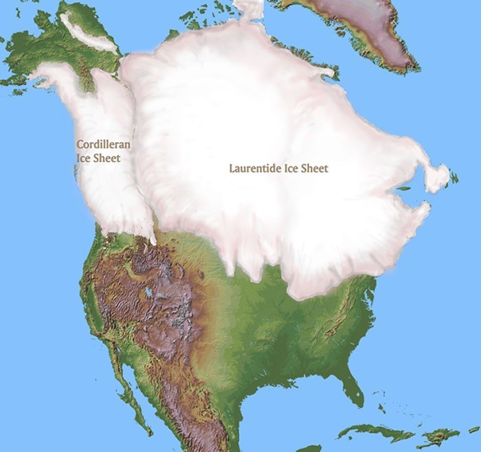
During the last Ice Age about 16,000 years ago, North America was covered by a massive glacier up to three kilometres (around two miles) thick in places.
As the ice retreated toward the end of the Ice Age about 12,000 years ago, it created the five Great Lakes and the melting ice began sending massive volumes of water from Lake Erie on the higher elevation to Lake Ontario on the lower elevation.
As the water drained from the upper lake over the Nigeria Escarpment to the lower lake it carved out the Niagara River and eventually created a waterfall.
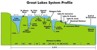
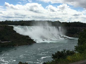
Today, the Niagara River flows almost 60 kilometres (56 miles) north from Lake Erie to Lake Ontario and forms part of the boundary between the province of Ontario in Canada and the state of New York in the USA (the border is in the centre of the river and lakes). Eventually it flows into the Atlantic Ocean via the Saint Lawrence River.
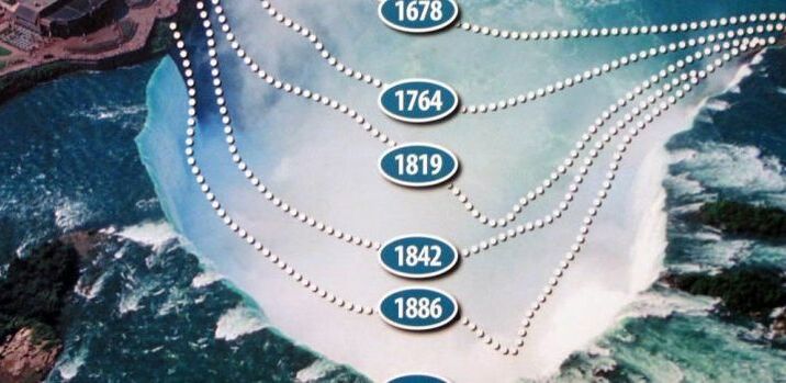
The sheer volume of the water plunged over the edge of the Niagara escarpment with such force that around a 1.5 metres, or some five feet of the limestone escarpment was worn away every year. In the 200 years before special works were undertaken, the erosion rate was as high as five feet a year, causing the face of the Horseshoe Falls to move almost a kilometre every thousand years (see graph below right of Falls movement over 200 years before remedial work was implemented)
Today, the Niagara River flows almost 60 kilometres (56 miles) north from Lake Erie to Lake Ontario and forms part of the boundary between the province of Ontario in Canada and the state of New York in the USA (the border is in the centre of the river and lakes). Eventually it flows into the Atlantic Ocean via the Saint Lawrence River.
The sheer volume of the water plunged over the edge of the Niagara escarpment with such force that around a 1.5 metres, or some five feet of the limestone escarpment was worn away every year. In the 200 years before special works were undertaken, the erosion rate was as high as five feet a year, causing the face of the Horseshoe Falls to move almost a kilometre every thousand years (see graph below right of Falls movement over 200 years before remedial work was implemented)
|
|
At more than 244,106 square kilometres (94,250 square miles), or slightly bigger than the whole of the United Kingdom, the whole Great Lakes and resulting river systems contain around 21% of the world’s fresh water and comprise the world’s largest fresh water system by area (if all that water from the system was on a flat surface it would cover every country in the North American continent with more than a metre of water).
During the late 1800s both the USA and Canada began using the power of the water to generate electricity, but there were always concerns about the erosion of the waterways.
In 1942, remedial works and the extension of power generation plants on the upper waters of the river in both countries dropped the water depth at the rim of the falls from three metres, or 10 feet, to just over half a metre, or about two feet, reducing the rate of erosion to between 10 and 30 centimetres, or less than one foot every year. Even so, scientists estimate that the river will cut through the escarpment and soft shale and erode back to Lake Erie on around 50,000 years, when it will begin to drain Lake Erie.
Currently there is significant water diverted from the main river flow into the hydroelectric systems - should that ever be stopped it is predicted that the Horseshoe Falls would again start receding at between one metre and 1.5 metres a year.
Why the Falls Recede
On the face of it, on would expect that the vast volume of water ploughing over the top of the falls would wear away the rim due to friction, but strangely that is not the only cause.
Much has been written about the millions of air bubbles created by the churning waters and plunge 50 metres to the water below, where they are forced another 50 metres underwater before they burst. The resulting impact sends millions of tiny shockwaves against the basalt and limestone base of the falls, which eventually degrade and collapse, bringing down the tonnes of rock above.
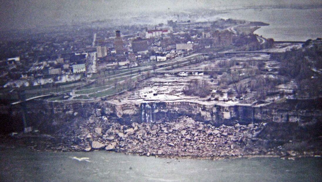
During the warmer months in 1969 the US Army Corp of Engineers built a dam across the river leading to the American Falls and diverted the water so they could geologically survey the rock face because they were worried it was being destabilised by erosion. The "dry" falls (below) show how the collapsed rock forms at the base of the Falls.
Much has been written about the millions of air bubbles created by the churning waters and plunge 50 metres to the water below, where they are forced another 50 metres underwater before they burst. The resulting impact sends millions of tiny shockwaves against the basalt and limestone base of the falls, which eventually degrade and collapse, bringing down the tonnes of rock above.
During the warmer months in 1969 the US Army Corp of Engineers built a dam across the river leading to the American Falls and diverted the water so they could geologically survey the rock face because they were worried it was being destabilised by erosion. The "dry" falls (below) show how the collapsed rock forms at the base of the Falls.
Niagara Parks, which manages the whole falls area, say the crest line of the falls was relatively straight until 1775, when the Horseshoe shape began to form. Two thousand years ago, the crest line of the Falls was located north of the current Rainbow Bridge, while 4,500 years ago the crest line was north of the current Whirlpool Bridge.
The shape of the crest line determines its stability. The uniform Horseshoe shape of the crest line of the Falls provides greater stability and the deepest plunge pools are carved out when the crest line of the Falls is relatively stable.
The American Falls has no regular mode of collapse and the present amount of water flowing over the American Falls is not sufficient to erode the limestone rock debris at the base of the Falls.
They say key contributors to erosion include:
With the American Falls and Bridal Falls, the water currently flows over limestone cap rock which is far more resistant to erosion than other rocks. Many years into the future, when the falls will reach a softer layer of rock, the rate of erosion is expected to increase once again.
The shape of the crest line determines its stability. The uniform Horseshoe shape of the crest line of the Falls provides greater stability and the deepest plunge pools are carved out when the crest line of the Falls is relatively stable.
The American Falls has no regular mode of collapse and the present amount of water flowing over the American Falls is not sufficient to erode the limestone rock debris at the base of the Falls.
They say key contributors to erosion include:
- The rush and flow of water breaks weak pieces of rock and carries them away.
- Due to the cold weather in the region, the constant freezing and thawing of the rocks lead to breakage.
- Rock falls which happen on and off weaken rock layers.
- Minerals which strengthen the rocks are also washed away when water lashes against the fissures in the rocks.
With the American Falls and Bridal Falls, the water currently flows over limestone cap rock which is far more resistant to erosion than other rocks. Many years into the future, when the falls will reach a softer layer of rock, the rate of erosion is expected to increase once again.
|
|
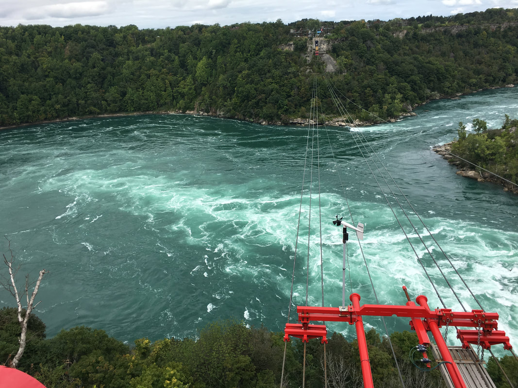
The American and Bridal Veil Falls as they are today and the WildPlay MistRider zipline that takes enthusiasts above the Niagara Gorge and Whirlpool, where a sharp right turn in the river creates Level 6 rapids.
The 1950 Niagara Treaty
Another factor little known by most people outside the broad Niagara region is that since 1950 there has been a treaty between the governments of Canada and the USA which specifies the amount of water that can be diverted over the Falls, protecting the three interests of Tourism, Power Generation and Falls Maintenance are best managed.
- It’s a formal agreement referred to as the 1950 Niagara Treaty, and basically allows the water flow to be reduced by 50% during daylight hours and 75% overnight, hence there is significantly less water flowing while most tourists are asleep.
- This is even specified in times and volumes - during the daylight hours of the tourist season (8am to 10pm hours in the warmer months from April 1 to September 15 and 8am to 8pm in colder months from September 16 to October 31st), the flow over Niagara Falls must not be less than 2,832 cubic metres per second. At all other times, the flow must not be less than 1,416 cubic metres per second.
- The treaty also specifies that only water that is not required for domestic and sanitary purposes, navigation and the falls flow can be diverted for power generation.
Visit Montreal
Find out about the Rocky Mountains
Back to Home Page
Send us your story
Visit Other North American Destinations - Canada, United States, Las Vegas, New York, Los Angeles, San Fransisco, New Orleans, Orlando, Mexico, Hawaii
Find out about the Rocky Mountains
Back to Home Page
Send us your story
Visit Other North American Destinations - Canada, United States, Las Vegas, New York, Los Angeles, San Fransisco, New Orleans, Orlando, Mexico, Hawaii
